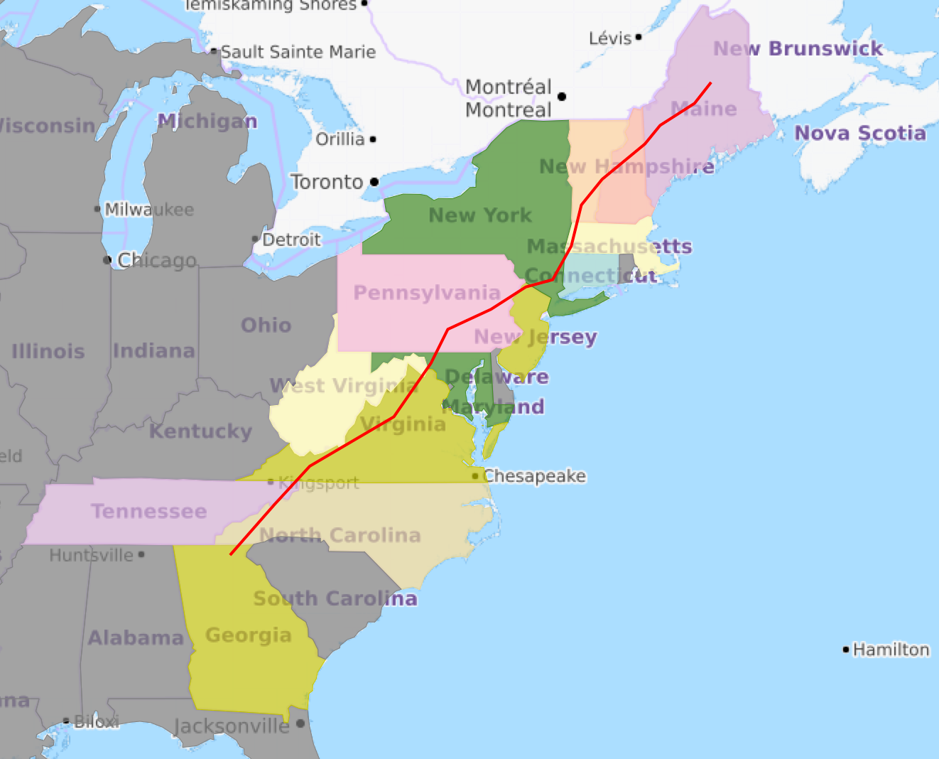
The Appalachian National Scenic Trail spans fourteen U.S. states during its journey that is 2,185 miles (3,516 km) long, including Georgia, North Carolina, Tennessee, Virginia, West Virginia, Maryland, Pennsylvania, New Jersey, New York, Connecticut, Massachusetts, Vermont, New Hampshire, and Maine.
Let’s take a look at America’s longest trail system, state by state, starting from the South. But first, a map:
Georgia: 79 miles of trails
The trail begins in the North Georgia mountains, which are nothing like the rest of Georgia. These mountains are substantial—with high, steeply grading peaks and tough hikes. This is not the peach tree, peanut plant Georgia you’ve read about or visited before, in fact, almost half of the A.T. in Georgia passes through federally designated wilderness, and it truly is wild.
It is recommended that you stay away in March and early April, since campsites are very crowded with thru-hikers and spring breakers, and the weather can be miserably cold at this time. Because of the height of these mountains, the snowfall and cold temperatures can rival some a thousand Trail miles north. You can encounter snow from November through March or April, and during cold snaps temperatures can dip to single digits. ‘Nough said.
North Carolina: 95.7 miles of trails
Though there are 95.7 miles of the A.T. in North Carolina, the Trail runs along the Tennessee/North Carolina border for 224.7 additional miles. As the A.T. ascends to the High Country of the state line, hikers traverse the highest mountains along the entire Trail, including several above 6,000 feet. This spans a difficulty rating from easy to challenging (1 to 7 on their rating system), and includes many breathtaking views and great campsites.
If you plan on visiting Great Smoky Mountains National Park, you will need to obtain a special advance permit, and depending on the length of your hike, shelter reservations as well. All backpackers are required to stay at designated sites along the trail.
Tennessee: 94 miles of trails
The description for this part of the trail is so similar (and in many aspects the same as) the description for North Carolina above, that we won’t waste your time writing it again.
Virginia: 554 miles of trails
More of the A.T. passes through Virginia than any other state (over 1/4 of the entire length in fact), and views from overlooks reveal incredible scenes that are a perfect mix of forest and farmland. And for those of you who are more interested in driving than hiking, in Shenandoah National Park alone, you can cross the A.T. more than 30 times without ever getting out of your car!
Shenandoah National Park, with 104 miles of well-maintained Trail and climbs rarely exceeding 500 or 1,000 feet, is great for beginners. Remember, though, that back country permits are required when camping in the park.
West Virginia: 4 miles of trails
The West Virginia section of the A.T. is mostly in historic Harpers Ferry, the site of John Brown’s Raid and several memorable Civil War battles. If you find yourself along this short stretch of the Trail, be sure to stop by the Appalachian Trail Conservancy’s headquarters, accessible off the A.T. via a 0.2-mile blue-blazed trail.
It is important to mention that there is no camping in the town of Harpers Ferry or Harpers Ferry National Historical Park. However, there are a number of commercial campgrounds nearby, and there are a variety of places to stay in town, ranging from B&Bs, hostels, motels and an inn. So if you’re a history buff, we recommend you spend some time exploring this part of the Trail.
Maryland: 40 miles of trails
The Appalachian Trail in Maryland follows a 40-mile route along the backbone of South Mountain, a north-south ridge that extends from Pennsylvania all the way to the Potomac River. This section of the Trail is also steeped in Civil War history and home to the original Washington Monument. This is perfect for three- or four-day hiking trips, and is considered easy by A.T. standards. It’s also a good place to find out if you’re ready for more rugged parts of the Trail.
Again, camping is allowed only in designated overnight sites. It’s best to hike here mid-April through mid-June or September and October. The summer heat and humidity can occasionally be pretty intense.
Pennsylvania: 229 miles of trails
This is the section of the Trail that I personally grew up on. Long, flat and rocky ridges characterize much of this state. The southern part of Pennsylvania offers some of the easiest walking of the entire A.T., but steep descents to rivers and gaps break the ridgelines in the northern two-thirds of the state. The Deleware Water Gap is one of the most beautiful sites along the trail, and is located near the border between Pennsylvania and New Jersey.
The A.T. passes through game lands managed for hunting, so fall is not the best time to go. All hunters and non-hunters are required to wear at least 250 square inches of fluorescent orange material on the head, chest and back combined, or a fluorescent orange hat, from Nov. 15 to Dec. 15 (except on Sundays) on state game lands in Pennsylvania (the area nearing the Delaware Water Gap (roughly the northern 2/3 of the state).
Only thru-hikers (defined as those “walking the Appalachian Trail from point of beginning to an exit, which is not the place of beginning) may camp on Pennsylvania Game Commission lands, and these hikers must camp within 200 ft of A.T., at least 500 ft from a stream or spring.
New Jersey: 72 miles of trails
New Jersey will surprise you with how wild it is, especially because of its proximity to major cities. Elevation changes are generally moderate and vary from relatively flat and gentle to short, steep, rocky pitches. Other sections cross bogs and wetlands, including a wildlife sanctuary that features a wide spectrum of bird and other wildlife species.
Camping on the New Jersey Trail is restricted to designated sites, and campfires are prohibited. It’s a good chance to practice “Leave No Trace” and enjoy an alternative “nightlight”!
New York: 90 miles of trails
In New York, you may see types of wildlife you weren’t expecting! The A.T. passes through a Trailside Museum and Zoo at Bear Mountain. At 124 feet, Bear Mountain is also the lowest elevation point on the entire Trail.
Be sure to consult your guidebooks and maps while planning overnight hikes in New York. Shelters are far apart and camping is limited to designated sites. Campfires are prohibited except in designated fire rings along the New York Trail.
Massachusetts: 91 miles of trails
Massachusetts is home to Mt. Greylock, the mountain said to inspire Herman Melville to write “Moby Dick”, and more recently, the site of JK Rowlings newest Harry Potter Book! At 3,491 feet, this mountain is the highest point in Massachusetts and rises above the surrounding Berkshire landscape. On a clear day, you can see dramatic views up to 90 miles in the distance. This is also known as the Fall Foliage capital of America, and for good reason!
Bus service is available in towns adjacent to the A.T. along Route 7. Route 7 roughly parallels the Trail between Kent, Connecticut, and Rutland, Vermont.
Vermont: 150 miles of trails
Vermont’s mountains aren’t called the Green Mountains for nothing! This section of the A.T. is characterized by dense and verdant forests. The 45 miles of A.T. at the east end of the state are lower elevation, but offer great autumn foliage and a chance to get away from the crowds.
Veterans of the trail warn to stay away during mud season, which runs from April through most of May.
New Hampshire: 161 miles of trails
New Hampshire features more miles above treeline than any other Trail state. This provides exposed ridges with amazing views when the sun is shining, as well as the worst weather in the world when storms hit, fair warning.
Special regulations govern the White Mountains due to the fragile nature of the alpine tundra as well as the danger that exposed areas pose to campers and hikers. The mountains are very steep here, and you need to be in seriously good shape with strong knees before braving them.
Maine: 282 miles of trails
Maine is the A.T.’s most challenging, rugged and remote state, and hikers agree that it has the wildest feel of any area of the Trail. Maine features some exciting things that are rare elsewhere on the A.T., including wildlife like moose and loons and pristine mountain lakes. It’s also famous for hosting the hardest mile of the Trail: Mahoosuc Notch.
Maine is famous for its unbridged stream crossings, which can be hazardous, especially after spring snowmelt and/or heavy rains. The Kennebec River, the wildest unbridged crossing, has a free ferry service in the form of a canoe during hiking season. This is the A.T.’s official and historic route; fording the river is extremely dangerous because the water level can rise rapidly and without warning.
With such a variety, through so many states, the Appalachian Trail is truly one of America’s greatest ways to get in touch with nature and enjoy time spent among the trees and pastures of the East Coast. Please share your experiences!
Latest comments